$29.99
Out of stock
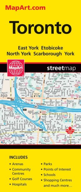
Toronto & Area Atlas – 1220
Are you looking to navigate Toronto and the surrounding areas with ease? Look no further than the Toronto and Area Street Atlas! With detailed maps of the entire GTA, you can easily find your way around the city and its surroundings. Whether you’re a traveller, commuter, or just navigating the streets of Toronto, Mississauga, Markham, Oshawa and more the Toronto and Area Street Atlas is the perfect tool for you. Get your copy today and start exploring!
Inside this 360 page atlas you will find city maps (1:20,000), regional maps (1:250,000), locator maps, GO Train system map, Toronto Path map, TTC subway and rapid transit map, Union Pearson Express map, feature listings (municipal halls/civic centres, transportation, hospitals, points of interest, recreation facilities, golf, wineries), Toronto Area Map with feature listings (points of interest, golf, parks, shopping malls, hospitals, airports, skiing, colleges and universities) and a detailed street index.
City mapping includes Ajax, Aurora, Beaverton, Bradford, Brampton, Burlington (Kilbride), Caledon (Bolton, Caledon East, Caledon Village, Cedar Mills, Palgrave), Clarington (Bowmanville, Courtice, Hampton, Newcastle, Orono, Solina), East Gwillimbury (Holland Landing, Mount Albert), Georgina (Keswick, Pefferlaw, Sutton, Udora), Halton Hills (Acton, Georgetown), Hamilton (Carlisle, Waterdown), King, Township of (King City, Nobleton, Pottageville, Schomberg), Markham (Unionville), Milton, Mississauga, New Tecumseth (Beeton, Tottenham), Newmarket, Oakville, Orangeville, Oshawa, Pickering (Claremont), Port Perry, Richmond Hill (Oak Ridges), Toronto, Uxbridge, Vaughan (Kleinburg, Thornhill, Woodbridge), Whitby (Brooklin), Whitchurch-Stouffville (Stouffville, Vandorf)
The detailed city maps features divided highways with collector lanes, divided highways, divided toll highways, major roads, secondary roads, main thoroughfares, minor streets, lanes / private streets, pedestrian streets, interchange numbers, one way streets, street address numbers, railways, VIA Rail Stations, GO Train Stations, Union Pearson Express, subway stations, LRT Stations, bus stations, ferries, carpool parking, municipal boundaries, recreation trails, parks / conservation areas, golf courses, commercial areas, cemeteries, institutional areas, industrial areas, special attraction areas, National Defence, hospitals, tourist information centres, police stations, fire halls, municipal / regional buildings, courthouses, libraries, points of interest, off leash dog parks, beer stores, liquor stores, historic sites, arenas, community / recreation centres, pools, baseball, soccer, tennis / pickleball, skiing, campgrounds, public and catholic schools
The back road maps features include expressways to seasonal roads, airports, train stations, ferries, locks, lock numbers, OPP, hospitals, customs, tourist information centres, rapids, waterfalls, beaches, peaks, mines, rest areas, skiing, golf, wharfs, boat launches, marinas, landmarks, campgrounds, UNESCO World Heritage sites, National Historic sites, bird watching, viewpoints/looksouts, lighthouses, National and Provincial parks, greenbelts, conservation areas, bird sanctuaries, populations and more.
Wire-O bound
Dimensions: 22 x 28 cm (8.5 x 10.875 inches)
Proudly made in Canada!